Tuesday, April 12, 2016

Death Valley: The Low Point of Our Trip

   
     Welcome to Death Valley

As I write, I am sitting in my bed/office/living room in the camper, it's about 9pm and feels like it's about 90 degrees, which it might be in the camper, outside its only about 75.  There are tiny little bugs that are swarming around the light, they are so tiny that they can sneak into the camper through the screens and as I type, I tap on the screen of my iPad every so often to kill the little critters that are crawling around. I have to get that out before I can go on about Death Valley, because currently they are making me very distracted. (Note: this is being published the next day after a buggy night filled sleep. Bugs kept falling through our vent above our bed, making for a warm, restless night. I loved this area and the warm weather during the day but the bugs and a camper without AC was not ideal in the evening.) 

Other than the night time bugs, Death Valley has been a really wonderful National Park. Both Andrew and I had little, to no expectations for this park. We thought it would be cool to drive through, maybe stay one day on our way to Zion. When we checked in on Sunday after leaving Lake Isabella we stopped at the Visitors Center, as we generally do when visiting National Parks, it's the best way to get familiar with the park, collect maps and talk to the park rangers. When we checked in the girls each got Junior Ranger packets and we also got the instructions for the #hikedeathvalley program they were currently running. Junior Ranger programs are fun because it give the girls something to focus on (we also gave them a pass on school work when they fill out the booklet) and we all learn new things about the park. (For example, we learned the highest recorded temperature was 134 degrees Fahrenheit in 1913!)  The #hikedeathvalley program was a fun challenge to get people hiking different trails in the park, each hike was worth a certain amount of points. Once you earned 4 points you get a Death Valley decal. Although, the decal isn't super fancy it was fun to plan out our hikes for our visit based on how many points we got for each and we all loved having a goal for the few days we were here. 

                                           
    Wildflowers from Dante's View  

Camping at Death Valley is not like most other National Parks, there are no trees, very little shade and you are pretty much camping in a parking lot. But for the nights we were here we enjoyed our spots (despite the bugs), the first night was in Furnace Creek, very close to the Visitors Center, where we got to see a ranger talk in the evening. The next two nights we stayed in Stovepipe Wells which is close to a general store and another lodge which has a restaurant and bar and a pool, which for $4 dollars we were able to enjoy, along with a nice shower – after a long day of hiking, this was the best $4 dollars I have spent in awhile. The best thing about camping out here in this vast valley is the magnificent stars that we have been able to experience each night. Without all the lights of a city and so much open space you can see for miles and it is truly amazing. 

For our first full day we started off with an easy hike/walk on the Badwater Basin, although this wasn't on our list for points,  it is the lowest point in the park at -282 below sea level. There is a boardwalk that takes you out to the basin to the salt flats which looks like it could be a frozen lake or covered in snow, but it is evaporated water and salt crystals and other minerals. It was fun to walk out on the basin and feel like we were in the middle of nowhere or in a scene out of Star Wars (which by the way, many Star Wars movies were filmed in Death Valley).
 
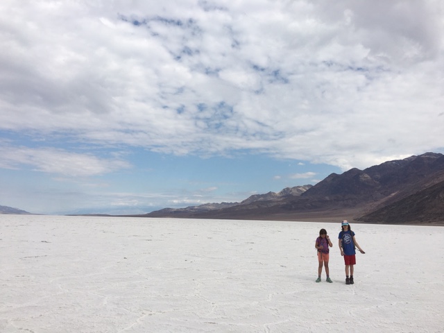
     Girls in the middle of Badwater   Basin

After the Badwater Basin, we traveled down the road a bit to another trail called Natural Bridge. This was also a shorter hike, through a canyon and under a Natural Bridge (hence the name) which was created through differential erosion, along the path there are also dry waterfalls and huge boulders to climb over and under. When the path ends, there are more rocks and boulders to climb around on and explore deeper into the canyon. While we were hiking it started to rain, big raindrops. And because I am a bit anxious at times and had read enough about flash floods in this park, I frantically insisted that our hike was over and it was time head down the canyon. Although, I may have been a bit overly cautious, by the time we got to the truck it was pouring and I was happy to be safely driving away to our next stop. 

                                   
   Hiking under Natural Bridge (1 pt) 

After the Natural Bridge, we took a driving tour through Artist’s Drive and Artist’s Palette. One crazy thing about this park is the weather patterns, even though it was dumping rain at Natural Bridge, it was warm and sunny just down the road on Artist’s Drive. This drive is a 9- mile, one way road, only open to vehicles under 25 feet (another reason we love our compact camper). The drive was narrow and curvy with big rocks overhanging. Not to mention the amazing colors and features on the mountains along the route. It was a lovely detour and once again I love my husband for his awesome driving skills and abilities of maneuvering our rig through these super, cool tight spots. 

                  Artists Palette

After Artists Palette, we needed some more points for our challenge (we didn’t get any points for the drive or Badwater, and only 1 point for the Natural Bridge), so we headed over to the Mesquite Sand Dunes. This crazy hike, with no trail or path, takes you over hot, sandy dunes and our goal was to get to the highest dune, about 1 mile away (as the crow flies). Once again we felt like Star Wars characters in the middle of the desert, it was hot and sandy and our shoes were filled to the brim with sand, but we thoroughly enjoyed hiking the ridges on the various dunes and running down like crazy people once we finally reached the top point. 

       Mesquite Flat Sand Dunes (1 pt)

The second day, we started off our day with a beautiful hike at Mosaic Canyon. This was my favorite hike of the visit, it was a nice climb up through marble canyon walls. And again, like Natural Bridge, once the main trail ends there are cool boulders and marble shoots to climb in and over. This also made the hike way more enjoyable for the girls, they don't love hiking in the burning, hot  sun, but once they are climbing and sliding various shoot and canyons they forget about the heat and love the adventure. Bonus, there was no rain at all for this hike! 
                            Nadia climbing the boulders at Mosaic Canyon
    Hiking Mosaic Canyon (2 pts)

After the hike, we had lunch in the camper by the Salt Creek Interpretive trail and checked out pupfish and then drove to Dante’s View, at 5475ft we got to look down on all the hikes we had traveled over the last couple days, our main view was over the Badwater Salt Flats, which was really cool and we also got to enjoy some more greenery and the blooming wild flowers that were starting to show up.

      Badwater Basin from Dante's   View

          Wildflowers at Dante's View

Hiking in the park was lots of fun and of course, as usual, we didn’t even really scratch the surface for what the park has to offer, there were longer hikes, hikes to waterfalls and tons of areas to explore when we come back in a smaller/lighter 4x4 vehicle. In the end, we reached our goal of 4 points and we each got a fancy decal for our accomplishments! 


Friday, April 8, 2016

California Highways

We just completed a decent day of driving, as we drove from Big Sur to Lake Isabella and managed to book end our day with what I believe are like the two wildest paved roads in California. The first road, California Highway 1 south of Big Sur to Cambria was intentional, I had driven this road before, I just forgot what the road was like. The last time I drove that road was with my friend Chris. We were in ‘88 Pontiac Grand Prix, a far better handling vehicle than my Ford F-350 with a camper on back. We were also in our mid-20s and still believing we were indestructible (in hind sight, we were definitely crazy to do that drive, as the breaks in that Pontiac Grand Prix were rather sketchy).

California Highway 1, better known as the Pacific Coast Highway is one of the most beautiful stretches of highway in North America. Even though the speed limit is 55 mph for most of the stretch we drove from Half Moon Bay to Cambria, it’s impossible to drive it at 55 mph (especially in a truck and camper), because of how windy and narrow the road is, and because it’s almost impossible not to stop every few miles to take in the endless view points. The incredible vistas are endless and there are several opportunities for wildlife viewing, like Elephant Seal Vista Point. Heading from North to South the road seems to get more narrow, and windy to a point where I, the driver, was nearly getting car sick. It is the only stretch of highway where I didn't feel like California drivers were constantly trying to angrily pass me. In fact the only person I had to pull over and let by was a California Highway Patrol.
The Pacific Coast Highway, where you don't want to take your turns wide
Molting juvenile elephant seals at Elephant Seal Vista Point 
After we got off of Highway 1, our choice of roads was completely unintentional. We are currently making our way to visit friends who are spending their Spring Break in Zion National Park. So we found a place to stay near Lake Isabella which seemed like a good day's drive from Big Sur as we made our way towards Zion National Park. The stop it left us with the possibility of an easy detour to visit to Death Valley National Park. I plugged into GPS where we wanted to go at Lake Isabella and it returned us with a route that, at a quick glance, appeared to be the simplest route. The route took us along Highway 1 to Cambria, then east on Highway 46, eventually 46 turns to Granite Road a beautiful road winding through the hilly California country side, eventually we ended up on Highway 155. Highway 155 steeply twists its way up over 6000 feet into the Greenhorn Mountains. Along most of Highway 155 it is difficult to get your vehicle up to 30 mph, despite the speed limit being 55 mph. Eventually the highway drops steeply back down to Lake Isabella. A truly beautiful drive, but a bit of a white knuckle drive in a truck camper with rain pouring down.
A moment without rain on the climb up Greenhorn Mountain on Highway 155
On this trip we have never passed up the opportunity for an interesting stretch of road (such as Beartooth Pass in Montana which my brother-in-law Dan recommended). However, Highway 1 and Highway 155 are definitely the wildest stretches of paved road that we have driven on this trip, and definitely among the most beautiful stretches of road (but the views had to be left to the passengers). I highly recommend anyone who has the opportunity to experience these two stretches of highway to do so. However, I recommend not doing it in a RV or even a truck camper. Consider a Porsche, or some other car that is light, with great handling, low to the ground, and with excellent breaks.

Wednesday, April 6, 2016

What Do You Want To Do? Want Do You Want To Be?

I felt that after a visit to Google and Facebook (thank you Patrick and Jarred) that I should write something about my daughters comments about their future career plans. Not that Kathy or I expect either of our daughters to have the slightest clue what they want to be, nor should we expect them to have any idea what they want to be or do. However it got us all talking.

Now of course when we were visiting the head quarters two of the best know companies in the world where meals are all free, laundry is free, gym facilities are free, and there are free bikes for anyone to use when ever they want, it's hard for a visitor not to say, "I want to work here!" (For the record John and Gary, I personally never said out loud that I wanted to work at either Google or Facebook. Kathy will attest to this. Not that any jobs were offered...). However, when we got back to where we were staying for the night I asked both girls to talk about all the different jobs we've seen that people do during this trip. The first words out of their mouth were, "We don't have to write a paper about this, do we dad?" I said they didn't if we could have a good discussion.

We talked about all the different jobs that we've seen people do on this trip: Clem and his winery in Maine, Sophia and her pop up kitchen's in Tennessee, Martha at Mockingbird Hill Farm in Georgia, Chaz on the ranch in Texas, Bob the water source expert in Utah, and of course Patrick at Google and Jarred at Facebook (along with many, many others). When they considered everything they had seen and experienced their opinions changed a bit. Siena said she wants to be just like Bob, exploring the mountains and rivers around Salt Lake City and testing the water quality. Nadia said she wants to be just like Sophia, a cook! (Sophia does a lot more than just cook, but if you check out her Instagram  account, you'll see why Nadia wants to be a cook like Sophia. Granted, by later in the night, both of their future career goals had completely changed again.
Clem giving the girls a tour of his winery in Maine
Sophia teaching the girls about essential oils (Sophia does more than cook)
Siena feeding the goats on Mockingbird Hill Farm
Chaz showing the girls how to feed each cow by hand, which he does every day
Nadia learning how they take naps at Google
The girls updating THE Facebook Wall
One part of why I wanted to do this trip was to show the girls a wide sampling of the sort of things people do for a living across America. I personally had no idea of the vast different career choices there were out there when I finished college. I had great plans for how we would try and see as many different sorts of jobs that people do across the country. In the end, I was never organized enough to put together a proper educational tour of careers across America. However, we have met lots of interesting people and saw lots of different ways of making a living. Perhaps the girls will look back on this trip some day in the future and be able to use the memories of this experience to open up possibilities that they might not have otherwise considered. For right now at least, I'm just happy that Siena is open to ideas other than moving to Hawaii and becoming an shark trainer, and Nadia is no longer dead set on being Taylor Swift when she grows up.

Sunday, April 3, 2016

Oregon Days and An End To Skiing (for now)

At the very tippy top of Mount Bachelor with Tom and Lisa
We finished up our skiing for this season with a beautiful bluebird spring skiing day at Mount Bachelor with our friends Tom and Lisa. Prior to that we spent 4 days skiing at Timberline, 2 days with our friends from Seattle Jen, Chris and Jaden and Lisa, Chris, and Zoe, and 2 of those days staying with just our family staying at Timberline Lodge. 
Skiing Timberline with Chris, Jen, Jaden, T-Bone, Lisa, and Zoe
It was great to see so many friends and difficult to spend so much time so close to home only to know we were going to turn around and head south again. However, it was several days of wet weather while staying west of Mount Hood that reminded me that summer most certainly had not come to the Pacific Northwest yet (not even sure that Spring had come yet). 

Frozen up at Timberline
While I did enjoy spending time camping with friends, it had been a very long time since we last found ourselves sitting around a campfire in the rain with umbrellas (which we did quite a few times at the start of this trip). It was that experience that got me to look through weather forecast maps of the western United States to try and find where the closest place was where I could find the warmest, driest weather after we left Oregon. What the long term forecasts were telling me was to head to California.


So as I write this Kathy is driving us to California. The plan is to make it south of San Francisco by Monday afternoon, and meet up with our friend April who we haven’t seen in quite a few years. After that we have a little over a week to get our gypsy wagon to Zion to meet up with more friends.


The skiing adventures this season have been incredible, and as much as I did miss my beloved Alpental, it will be difficult for our family to get used to Pacific Northwest skiing next season. Although we didn’t start skiing until February, we got 27 days of skiing in, we skied in 4 states, 11 ski areas, and we had very few overcast days or even snowy days. Our friends Brandon and Sabrina flew to New Mexico to spend a weekend skiing with us there. In Utah, my brother Alex skied with us at Snowbird, and we were joined by my brothers good friend Bob. And finally in Oregon we skied with all the friends I previously mentioned. Most of the skiing for us this season were beautiful bluebird days, and even several fresh powder bluebird days (as a Pacific Northwest skier this is something I had previously only heard of in legends). Despite the amazing 2 months of skiing, Kathy and I were sick of dealing with a family of 4 and all of our skis and ski gear piled into a tiny box on the back of a pickup truck. Every time we stopped for the night somewhere, all the ski gear had to be moved from the the piles covering our beds in the camper to filling up almost every inch of the cab of the truck. Luckily, our friends Tom and Lisa graciously agreed to store all of our ski gear for the last two months of our trip.


Now as I finish this post and we are just a few miles from the California border, I am starting to get excited by the realization that this adventure is going to transition back to the same type of adventures that we started this trip with: hiking and exploring the wild places of the west coast! With that said, next stop, San Francisco!


One final unrelated note, according to my trucks computer we’re currently averaging 11.9 miles per gallon, just thought I’d mention, because I get asked that a lot.